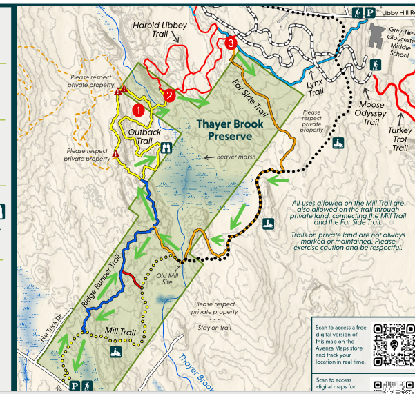
In 2022, a new land preserve, Thayer Brook Preserve, opened next to Libby Hill Trails. This additional 147 acres provides an additional four miles of trails that can be combined with Libby Hill Trails allowing lots of loops that hikers can choose to take. You’ll experience Thayer Brook, Thayer Marsh, boulder ridges, an old mill site, and prime pine oak forests. This hike can be done starting from two different parking areas. Both hikes are shown below.
Starting from Ramsdell Road (3.8 mi.)
Summary
Trails: Mill –> Ridge Runner –> Outback –> Harold Libbey –> Lynx –> Far Side–> Ridge Runner –> Mill
Distance: 3.8 miles
Options: Outback Loop (1), Harold Libbey Loop (2), Moose Odessey (3)
Detailed Description
A parking area for the preserve is located at 92 Ramsdell Road. Begin your by starting the trail by the large boulder near the trail kiosk. This is the Mill Trail which after 300 feet becomes an active ATV/Snowmobile trail. Follow this trail which climbs two small hills and has two bridges crossing wet areas. At one-half mile you will take the Ridge Runner Trail on your left that is blazed blue. This trail starts on an old logging road then turns right between some boulders and works its way through a boulder ridge. As you crest the ridge, you’ll see Thayer Brook marsh in front of you. The trail begins following around the marsh. Please keep pets closely leashed in this sensitive wildlife area. In 400 feet you’ll come to the junction of the Outback Trail of Libby Hill (yellow). Turn right on the trail and continue following the marsh where you’ll come to a wildlife viewing area on your right.
You’ll now leave the marsh and proceed on the Outback trail where after 1/3 mile you will come to a junction (Red 1 on map). Your option here is to turn right and cross the bridge over Thayer Brook or if you want to have a shorter hike, go straight and do the complete loop of the Outback Trail then return back the way you came on the Ridge Runner Trail.
400 feet after crossing Thayer Brook you’ll come to the junction of the Harold Libbey Trail (red blazes). Proceed right onto the Harold Libbey where the next junction has red blazes (Red Number 2 on map) in each direction. You can optionally take a left here and return in a loop to the Outback, however, for the full hike keep straight. After 1/3 mile you’ll ascend Libby Hill and come to the junction of the Lynx Trail (Blue). Once again you can use this area (Red Number 3 on map) as an optional hike to loop onto any of the trails at the top of Libby Hill.
After starting down the Lynx trail from the Harold Libbey junction (150 feet) you will see the Far Side (formerly called Upper trail) Trail junction on the right. Take this trail which will take you on a gradual descent of Libby Hill through a beautiful pine oak grove. After 1/2 mile the trail turns right on to a wider snowmobile section. Proceed on for 1/4 mile into the woods. Note the snowmobile trail goes straight but the new Far Side section takes you on a loop into the woods. After looping through the woods you come out to the Thayer Brook Bridge, The orange trail proceeds uphill with a bench that has a view of the stream and beaver dam. Be sure to check out the stonework from an old mill here and the two beaver dams that create interesting waterfalls. The Far Side trail continues on for 400 feet where it ends at a junction to the Ridge Runner trail. Take a left here and follow the Ridge Runner back to the Mill trail and parking lot 1/2 mile beyond.
After leaving the brook crossing it is 3/4 of a mile back to the parking area on Ramsdell Road.
Starting from Libby Hill Trails Parking Area
Summary:
Trails: Lynx –> Upper –> Mill –> Ridge Runner –> Harold Libbey –> Lynx –> Moose Odessey (use Lynx in Winter)
Length – 4.5 miles
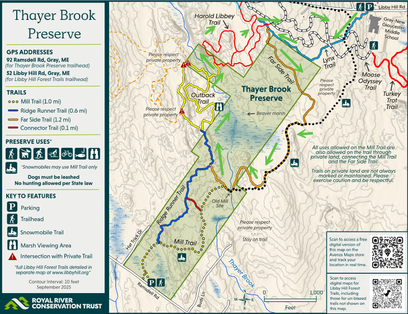
Detailed Description
Proceed diagonally to the Lynx trail which is across from the Libby Hill parking lot by the middle school. You will see several unmarked trails for the first 500 feet, stay on the marked blue trail. You’ll cross the Moose Odessey (White) trail twice including going over a bridge near the first intersection.
You now begin climbing up Libby Hill along an old barbed wired property line. If you look closely at some of the trees you can still see the barbed wired. After 1/2 mile you will turn left by a mini kiosk which marks the entry to Thayer Brook Preserve and the Upper Trail. This trail winds down an old logging road through a beautiful pine oak grove of trees.
After 1/2 mile you will reach the junction with the ATV/Mill trail. Take a right onto the Mill trail. This is an active ATV trail so move off trail when motorized vehicles approach. After 1/4 mile you’ll come to a bridge that crosses Thayer Brook. Look closely to see the old mill site that once occupied this site. You will also see two beaver dams that helped create the Thayer marsh. Continue on the Mill trail for another 1/4 mile where you’ll see the junction of the Ridge Runner Trail on your right. Proceed up the Ridge Runner trail which takes you through a beautiful boulder ridge which will bring you up to Thayer Marsh. The trail ends at the Libby Hill Trail system’s Outback trail (yellow) where you will take a right to continue skirting around the marsh.
After 650 feet you’ll come to a prime wildlife viewing area on the marsh. Continue on for 1/3 mile where you come to a junction in the Outback, take the right trail where you’ll see the new Thayer Brook bridge in front of you. If you take a break on the bridge and look down at the brook you can often see small trout swimming in the water. After another 400 feet you’ll come to the Harold Libbey junction (red). Turn onto the trail to the left which will take you up over a moraine ridge that looks down over Thayer brook.
You’ll continue on the Harold Libbey trail for another 1/2 mile where you’ll climb back up Libby Hill. Be aware that there is a red trail junction just before the bridge which loops back around the Harold Libbey, avoid that trail on the right an proceed straight across the bridge. At the top of the hill you’ll see a junction with the Lynx trail (blue) on your right, take that trail for 300 feet where you come to a major trail junction of the Lynx and the inner loop of the Harold Libbey. Turn left here to go up the knoll to meet the Moose Odessey Trail (white). Here on the right you’ll see a circle of sitting rocks by the monument to Harold Libbey, a perfect place for a break. Follow the wide Moose Odessey trail on the left back down to the school. You can go down either wide trail on the left. A short groomer access trail (yellow/white blaze) connects both of these together on top of the hill. Your choice on which you want to descend back to the parking lot which is 1/2 mile below next to the school. Note during ski season when trails are groomed you will need to return to the parking lot using the blue Lynx trail.